DISARM ICE --- LET THE POLICE CATCH REAL CRIMINALS --- DEMAND ACCOUNTABILITY --- KEEP AMERICA SAFE FOR EVERYONE ---
Showing posts with label Google Earth. Show all posts

Monday, May 3, 2010

a great slice

Our nicest morning walk in San Francisco started out in North Beach at Lombard and Columbus.


We walked up the hill to Coit Tower and enjoyed the view from there of the Bay and both big bridges.


Back down to Columbus and up to Grant for a brief stop at City Lights. They've got a nice selection of books, but I wonder how long they'll stay around in an IPAD world.


We walked the length of Grant through Chinatown, picking up some elegant little outfits for the grand-daughter, and made a stop at the kite store. I was disappointed to see they no longer stocked either the Indian fighters or the Japanese hatas.


We went back down Columbus and took a right turn on Green to get to the hole-in-the-wall Golden Boy Pizza. We each had a slice with everything on it and a beer. The crust was crispy, but not tough. Molto gustoso!

Wednesday, April 14, 2010

two views

These two images of the house we live in were made recently using tools which are quite widely spaced on the imaging technology spectrum. The photograph is from my Argus AF, one of the first American-made 35mm cameras which dates from 1937.


The drawing is a screen capture from Google's SketchUp 3D rendering program. I don't know if I'll achieve the skill level needed to produce something as complex as an aircraft design, but I'm pretty happy to have gotten this far with the program.


The SketchUp program is free for downloading, and Google also maintains an on line warehouse of images produced by users with impressive talent and skills.


The program has become the tool of choice for all kinds of model design. 3D building representations are being used to construct on line cities in Google Earth. Card modeling designers build aircraft in computer space and then use another program to unfold the surfaces for assembly. The computer generated designs can also be directly translated to real-world objects using 3D printers or computer-directed milling machines such as the one illustrated in this Daishin YouTube video.

Saturday, April 10, 2010

time travel

I alluded to this subject briefly on my other blog from a photo-aesthetic perspective. I want to elaborate the topic a bit further here because I think it provides a good illustration of some of the marvelous tools that have recently become available to historians, urban planners and all the rest of us.


I snapped the above picture recently during a morning bike ride. The focal point was the Mini-Cooper, but I was also conscious of the fact that Lee Friedlander had pictured the same place from across the street with a focus on a black dog in 1975 as shown below.


The Street View feature of Google Maps lets me see the scene from the same place and perspective that Friedlander witnessed about thirty years earlier. I believe the Google photo vehicle passed the site four or five years ago based on the way it portrayed the details of the house I now live in a few blocks away.


Google Earth allows a dynamic adjustment of the viewpoint which incorporates composite images built from satellite views, aerial photos and computer-generated 3D building representations.


One fact that emerges clearly in these pictures is that Albuquerque's urban core has changed relatively little over a period of three decades.


By contrast, zooming out a bit in Google Earth, one can see some of the vast suburban sprawl that grew outward to the horizon just since Friedlander's visit to Albuquerque.

Thursday, April 8, 2010

the last flight

I won't win any prizes for my model of the Grumman Duck bi-wing amphibian, but building it has been a nice way to tease out some memories of times long past. The Duck was the last single-engine plane I flew in.


The one I made my last flight in, like a lot of other old war birds, went to South America as war-surplus to haul cargo. A half dozen versions of the Duck were produced, the last having a 1,050 hp air-cooled radial engine.


In early 1960 I found myself just north of Colombia's southern boot heel at a mission outpost on the Mirití-Paraná River. I enjoyed my visit immensely, but after a month there I needed to get back to Leticia on the Amazon where I could get a plane back to Bogotá. The up-river trip in a series of increasingly smaller river boats had not been so enjoyable, and I was not looking forward to repeating that ten-day ordeal down to the Caquetá, and then up-stream on the Amazon to reach Leticia.


By good luck a tropical fish exporter based in Leticia was just then experimenting with the old Grumman Duck as a means of hauling his fish out of the rain forest so that they could be sent on to Miami, usually by means of some converted WWII bombers which made regular stops in Leticia. When the pilot of the Duck offered a ride to a friend and I, it was too good a chance to pass up.

(My memory of the flight's beginning is a bit fuzzy.  The Miritiparaná River is too narrow at the mission location to permit landing the Grumman Duck thereOn giving it some further thought I recall a downstream trip from the Miriti mission to the closest town of La Pedrera on the Caquetá.  I remember the river being muddy and shallow, and we had to get out to drag and push our riverboat for a long way, thinking all the while about the stingrays that lurked below.)

We rode down in the cargo compartment, accessed through the square hatch just behind the lower wing. We shared the cramped space with some water-filled plastic bags for fish, and one large up-ended turtle. It was difficult to see out during the ride, but the view was not very interesting anyway -- just the unbroken green canopy of the tropical rainforest. With a cruising speed of 150 mph, the Duck got us to Leticia in a bit over an hour.


Judging from the Google Earth view, the place hasn't changed much in half a century.

Wednesday, March 24, 2010

a virtual j-3 cub

This J-3 Cub can be flown in the Google Earth Flight Simulator. Download the file, J-3 Cub.kmz from my web site. The instructions for installing and using the plane's image are the same as for the T-6 Texan as explained in the first post on this blog. (The prop is not animated on the J-3 as it is on the T-6.)


My J-3 Cub is a card model. If you would like to build one, the pattern is available as a two-page pdf file which can be downloaded from the New Mexico Aerospace Education web site. The model's parts print out nicely, and can then be easily cut out and assembled in a couple hours.


Here are the specs for the J-3 from Wikipedia:

General characteristics
Crew: one pilot
Capacity: one passenger
Length: 22 ft 5 in (6.83 m)
Wingspan: 35 ft 3 in (10.74 m)
Height: 6 ft 8 in (2.03 m)
Wing area: 178.5 ft² (16.58 m²)
Empty weight: 765 lb (345 kg)
Useful load: 455 lb (205 kg)
Max takeoff weight: 1,220 lb (550 kg)
Powerplant: 1× Continental A-65-8 air-cooled flat four, 65 hp (48 kW) at 2,350 rpm

Performance
Maximum speed: 76 kn (87 mph, 140 km/h)
Cruise speed: 65 kn (75 mph, 121 km/h)
Range: 191 NM (220 mi, 354 km)
Service ceiling: 11,500 ft (3,500 m)
Rate of climb: 450 ft/min (2.3 m/s)
Wing loading: 6.84 lb/ft² (33.4 kg/m²)
Power/mass: 18.75 lb/hp (11.35 kg/kW)


In the interest of an authentic flight in Google Earth's simulator, you'll want to select the slower SR22 configuration, and maybe also cut back the throttle by about half.

If you happen to come upon an actual J-3 Cub gathering dust in your grandfather's barn, you can download Piper's detailed manual on how to fly the plane. In the 1940s you would have had to pay a dime for the manual, but thanks to the Internet you can have it free. As for the plane, if your granddad's barn doesn't have one, you can pick one up on ebay for around $20,000.

Monday, March 15, 2010

hello world

I need a place to talk about some of my interests without cluttering up my other blog and web site which are devoted to photography and old cameras. So, this is it.

My current obsession is Google Earth's Flight Simulator, which I only recently discovered. The 3D graphics and the interactive possibilities seem astounding to me. To kick things off, I thought I would start by sharing an aircraft image which I created to work with the GE Flight Simulator. The download (T-6 Texan.kmz) is available from my web site.
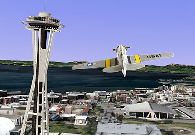


The KML script that powers the T-6 Texan was developed by Amir B and featured in a posting at the Google Earth blog. His script is accompanied by a nice selection of plane images which include a bit of animation, and work very well. I thought it would be nice to make my own, so I photographed a detailed model of the classic T-6 trainer and manipulated it in Photoshop to be a drop-in replacement for Amir's ME-109.

To fly the T-6 Texan you will first need to download and install the current version of Google Earth as well as the above T-6 Texan.kmz file. Double clicking the kmz file will run Google Earth and display the plane in the center of the screen.

Start the animation by clicking on the button above the slider bar at the top of the page. Then, type in a "Fly To" destination and press Enter to zoom there. To start the flight, click "Tools/Enter Flight Simulator", or Ctrl+Alt+A. At that point you will be offered the option of two types of aircraft, an F16 jet or a prop-driven Cirrus SR22. The performance characteristics of the T-6 Texan are similar to the SR22, so that is the one I usually choose. Click your mouse on the screen at the start of the flight to obtain control, then move the cursor left, right, up and down to navigate. The PgUp and PgDn keys control the throttle.

Additional instructions for using the Google Earth Flight Simulator are linked in the posting cited above.