Tuesday, March 30, 2010

a plane in every garage

A lot of people learned to fly during WWII. That fed nicely into the idea promoted by small plane manufacturers that one day everyone could enjoy the freedom of flying their own plane. There was in fact a great development of air travel and personal flight opportunities, though the details and diversity went far beyond what was imagined during Flight's first half-century. As it turned out, commercial and technical developments, along with societal changes, pushed small planes toward ever-increasing performance and price. By the mid-'50s the Piper Cub had morphed into models with several times the range and capacities of the original. One of my last flights in a single engine aircraft - and by far the longest - was in a Piper Tri Pacer.

In my second year at the University of Washington, my studies seemed to be taking me nowhere, so when an opportunity arose to join a project to make a film in the Amazon, I jumped in along with three other students. The group's leader was a tough little Greek guy who had just barely survived the Korean War and had ambitions to produce TV adventure stories. The photographer was a musician/biology student who happened to own a Speed Graphic and a 16mm Bolex. Transportation was provided by a pilot who had put in about four hundred hours in his Tri-Pacer. Since I had managed to struggle through several years of Spanish in my pre-college days, I was designated the interpreter. That was a good tip-off about the prospects of success for the venture.

Ahunt-Wikipedia

As it turned out, the plane trip was the best part of the grand adventure. We took off from Seattle in December of 1959 with the objective of reaching the Amazon River in southern Colombia. Stops along the way included Mountain Home Idaho, Panguitch Utah, Nogales Mexico, Mexico City, Merida, Managua, Panama City, and Medellin in Colombia.


When we got to Bogotá aviation authorities there quite sensibly concluded that our going in the Tri-Pacer over hundreds of miles of rain forest to Leticia on the Amazon was a recipe for disaster. So, we left the little plane behind in Bogotá and made the final airborne leg of the trip in a C-46. From Leticia, we traveled a thousand miles by river launch up tributaries of the great River and did our filming along the way. But, that is another story, as is my very last flight in a single-engine aircraft.

Friday, March 26, 2010

air space

Albuquerque radio control model flyers have a great place to practice their craft at the Maloof Air Park on the city's west side as seen in the Google Earth image below.


The well-appointed park is the busiest in the city system with many planes in the air every day, weather permitting.


A majority of the planes are gas-powered, but there are also many electric models. Large areas are reserved for helicopter flights and for rocketry.


Thursday, March 25, 2010

A current exhibit at the UNM Maxwell Museum of Anthropology takes note of the fact that a lot of shells and bombs used on both sides during the Korean war were filled not with explosives but with propaganda leaflets aimed at encouraging defection. A special target of that effort by the U.S. side was the Mikoyan-Gurevich MiG-15 fighter.


Pima Air and Space Museum, Tucson AZ, March 2007

The Soviet-designed fighter was a formidable foe that was fast, maneuverable and armed with 23mm and 37mm cannon. The heavy armament and 51,000 foot ceiling of the MIG made it a particularly serious threat to U.S. heavy bombers like the B-29.

According to the exhibit, about 1.5 million leaflets written in Korean, Chinese and Russian, and specifically encouraging defection by a MIG-15 pilot, were dropped on North Korea.


A Korean pilot, No Kum-Sok, did deliver a MIG-15 to Kimpo Air Base in South Korea, but it was nearly two months after the peace accord was signed, and he said the leaflet campaign played no role in his decision to defect. Though he was a bit late for the party, No Kum-Sok was still found eligible for the $100,000 reward offered in the leaflets. And,U.S. military leaders knew that the cessation of hostilities in Korea did not mean they had seen the last of the MiG-15.

Wednesday, March 24, 2010

a virtual j-3 cub

This J-3 Cub can be flown in the Google Earth Flight Simulator. Download the file, J-3 Cub.kmz from my web site. The instructions for installing and using the plane's image are the same as for the T-6 Texan as explained in the first post on this blog. (The prop is not animated on the J-3 as it is on the T-6.)


My J-3 Cub is a card model. If you would like to build one, the pattern is available as a two-page pdf file which can be downloaded from the New Mexico Aerospace Education web site. The model's parts print out nicely, and can then be easily cut out and assembled in a couple hours.


Here are the specs for the J-3 from Wikipedia:

General characteristics
Crew: one pilot
Capacity: one passenger
Length: 22 ft 5 in (6.83 m)
Wingspan: 35 ft 3 in (10.74 m)
Height: 6 ft 8 in (2.03 m)
Wing area: 178.5 ft² (16.58 m²)
Empty weight: 765 lb (345 kg)
Useful load: 455 lb (205 kg)
Max takeoff weight: 1,220 lb (550 kg)
Powerplant: 1× Continental A-65-8 air-cooled flat four, 65 hp (48 kW) at 2,350 rpm

Performance
Maximum speed: 76 kn (87 mph, 140 km/h)
Cruise speed: 65 kn (75 mph, 121 km/h)
Range: 191 NM (220 mi, 354 km)
Service ceiling: 11,500 ft (3,500 m)
Rate of climb: 450 ft/min (2.3 m/s)
Wing loading: 6.84 lb/ft² (33.4 kg/m²)
Power/mass: 18.75 lb/hp (11.35 kg/kW)


In the interest of an authentic flight in Google Earth's simulator, you'll want to select the slower SR22 configuration, and maybe also cut back the throttle by about half.

If you happen to come upon an actual J-3 Cub gathering dust in your grandfather's barn, you can download Piper's detailed manual on how to fly the plane. In the 1940s you would have had to pay a dime for the manual, but thanks to the Internet you can have it free. As for the plane, if your granddad's barn doesn't have one, you can pick one up on ebay for around $20,000.

Tuesday, March 23, 2010

for the birds

This small collection of hoods is about the only thing I have left from ten years in falconry. After I had mastered some of the intricacies of building and flying fighter kites, it seemed a natural progression to move on to hawks and falcons. It was a bit of a stretch undertaking this while living in San Francisco's Outer Mission District, but it turned out for me to be the right time and the right place.


I started out as everyone must with kestrels and red tail hawks. The kestrels were great little flyers. My Red Tail got to be very adept at catching ground squirrels and jack rabbits on the fill-land flats east of San Bruno Mountain. I also hunted there with my Salukis, but never achieved the bedouin ideal of working the birds and dogs together.


The pursuit of falconry ultimately contributed to a disaffection with city life. One day, we loaded the kids, the Red Tail, the dog and a friend from down the street in the Ford Econoline and headed for southern Idaho. The Snake River valley was the great center of modern falconry then, and I had the opportunity to fly some fine birds including Prairie Falcons and goshawks.


I did little photography during those years as falconry is a demanding taskmaster that permits no distractions. There are a few pictures somewhere, though. I'll dig them up eventually.

Monday, March 22, 2010

Albuquerque's claim on aviation history

Quite a lot of aviation history is housed in Albuquerque museums. The city's Art Museum, for instance, has two superlative collections related to aviation, and many examples of them can be viewed on line. The Museum's Flickr set of photos on the Albuquerque Municipal Airport contains a look at the style of commercial aviation at mid-Century that is stunning in its quality.


A lot of the pictures look like they were commissioned with promotional intentions, but the realities of the times they portray come through just fine. Most of the airliners are DC-3s and Constellations. There is also a glimpse of the adjacent Kirtland Army Airfield in which the photographer has captured no less than eight B-29 bombers.


Of even more historical interest is the set of photos which is currently on exhibit at the museum, the Frank Speakman Collection. The selection shown on line at Flickr covers most of the life of the first Albuquerque Airport, from the time it was established by Speakman in 1928 until it was taken over by the the Air Corps near the onset of WWII.


Right from the start, two of the early commercial airlines flew Ford and Fokker Tri-motors in and out of Oxnard Field, as it was known shortly after its opening. As time went on, just about every major air celebrity passed through Oxnard including Lucky Lindy and (unlucky)Amelia Earhart. Planes in the great air races of the 1930s such as the Bendix also frequently made Albuquerque a stop on their way, including this magnificent Wedell-Williams Special in 1934.


The Google Earth image below shows the east end of the main field of the present-day Sunport. At the top-center of the picture it is possible to discern some remnants of the original Albuquerque Airport as it was first developed by Speakman. The diagonal track going up to the left is the smaller of the two runways; it intercepted the mile-long main runway at its eastern extreme.


The image below shows a closer view of the location of the old airport; it provides a perspective similar to a high quality aerial photo made of the airport in 1931 from what I would judge to be about eight hundred feet above the ground. The photo is not one included in the Flickr set.


While visiting the exhibit yesterday at the museum, I made a quick sketch of the early aerial photo showing the position of the runways in relation to the mountains east of Albuquerque, as well as the main airport buildings. It looks to me like they were located right near that major T-intersection at the lower left.


It would be fun to superimpose an image of the photo on the Google view, or on a current aerial from the same perspective. No doubt many other features of the early installation could be identified.

Aeronca Adventure

The Aeronca Champ appeared immediately after the end of WWII. It had an appearance and performance characteristics similar to the Piper Cub, but with some design refinefments that made it a bit more comfortable flyer. Foremost among these was a taller cockpit and a weight distribution that allowed a solo flyer to sit in the front seat.


Wikipedia

We spent a lot of time in Aeroncas around the time I was ten or twelve thanks to my uncle Jack who piloted planes for some Seattle department store executives. The float planes were especially handy for getting into remote Cascade lakes with good supplies of rainbow trout.

A favorite spot for those airborne fishing outings was a small lake surrounded by steep fir-covered peaks that took some tricky flying to get into. Once, after stowing the inflatable boat and starting the takeoff run, my uncle noticed the plane listing a bit to one side. He showed me how to steer with the rudder pedals and then got out on the float to see what the problem was. I wasn't tall enough to operate the pedals and see out at the same time, so he yelled out directions.

It turned out that we had grazed a submerged snag and put a small hole in one pontoon. I think he may have tried to bail out some of the water with the pump from the boat, but he soon hopped in and headed us quickly back to shore, beaching the plane near a group of boy scouts who had hiked in to the lake. They helped us pull the plane all the way up onto the beach. Jack stuffed some rags into the breach, the boy scouts helped push off the plane, and we made a hasty takeoff from the lake.

Jack had more harrowing adventures flying in three wars, but the trip in the Aeronca was one of my more memorable flights.

* * *


Aeronca Ad, Popular Science, July 1946, p.219

Friday, March 19, 2010

taking control

I picked up this Logitech Wingman joystick at my local used computer store. It works pretty well with the Google Earth Flight Simulator to control aileron and elevator movements. The small silver handle at the lower left is the throttle control. For flaps and rudder, I still have to resort to the keyboard. The simulator actually works fine with a mouse, but the joystick is more intuitive and more fun.


Serious sim players are more likely to use a box with a couple of thumb sticks like the fellow in the picture below made at Albuquerque's Balloon Museum. He is operating a sophisticated radio control model simulator with the same kind of controller that would be used to directly operate an rc model. While it may be a bit ironic to be simulating a simulation, the strategy does have the practical benefit of getting practice on the same equipment that will be put to use when an actual flying model is at risk.


The Google Earth Flight Simulator has built-in support for a number of joysticks. The path to the initialization files is C:\Program Files\Google\Google Earth\client\res\flightsim\controller. An explanation of the button assignments will be found in the generic.ini file.

The guide to the flight simulator keyboard controls is at the Google Earth site.


An aspect of all this that appeals to me is the opportunity to move easily back and forth between the real and the imagined. Someone who considered that idea a good while ago was the author who coined the term, "cyberspace", William Gibson. In 1985, together with Michael Swanwick, he produced the short story, Dogfight in which the main character becomes obsessed with a game of combat by tiny holographic WWI fighter planes which are controlled directly by the mind. That is probably my favorite of Gibson's work. I think I lost the anthology in which it appeared, Burning Chrome, during our last move. There is a pirated copy of Dogfight parked on a Russian server, but the other stories in the collection are worth reading as well.

Thursday, March 18, 2010

T-6 Gallery

The North American T-6 Texan which I chose for my blog's logo has been a long-time favorite photo subject. I find the design's combination of strength and grace very appealing. About 15,000 were built between the mid-'30s and the mid-'50s, and there are still many flying.


Cutter Aviation, Albuquerque NM, July 2009


Pima Air and Space Museum, Tucson AZ, March 2007


Pima Air and Space Museum, Tucson AZ, March 2007


War Eagles Museum, Santa Teresa NM, December 2003


War Eagles Museum, Santa Teresa NM, December 2003


War Eagles Museum, Santa Teresa NM, December 2003

first flights

My first plane ride was either in an Aeronca or a Piper J-3 Cub; I would have been eight or nine years old at the time. They were both popular planes in the late 1940s. My mother, my grandfather and my stepfather all took flying lessons in those small planes, though they would later move on to the sleeker and faster Cessnas.


The J-3 Cub in the photos was flown in December 2003 at the Centennial celebration of the first Wright Brothers flight. The location was the Santa Teresa, New Mexico air field where I went many times to see and photograph the planes at the War Eagles Air Museum.

The stars of the December 2003 airshow were the big Collings Foundation bombers, but it was great to see the little Cub get into the air. Particularly in the context of the other planes being flown that day, the slow take-off and flight speed attained by the J-3 Cub seemed hard to believe.


That kind of buoyant, low and slow flight is very appealing to me, which probably explains my attraction to the Google Earth Flight Simulator. I'm going to make or acquire a model J-3 sometime soon to insert into the program so that I can recreate something of the experience of flying in that great old classic.


Piper Aircraft Corporation Ad
Popular Science, April 1938, p.117

Tuesday, March 16, 2010

wind driven

I've been obsessed with the idea of flight as long as I can remember. However, I don't think I ever really seriously considered piloting an aircraft of any kind. It's the idea at a somewhat abstracted level that is appealing, and the experience I have sought is vicarious or virtual flight. I suppose it started for me with watching birds and planes in flight and imagining some connection to them.


Popular Science, Aug.1936,p.69

Like most kids, I soon moved on to flying kites. In those days, there seemed only to be two available choices. One flew either a diamond-shaped stick kite or, for a bit more of an investment, you could hoist a box kite. We usually chose the diamond based on the availability of a meager allowance, augmented with earnings from collecting bottles to be turned in a the local grocery, coincidentally also the kite store.

Seattle often has gusty wind conditions in the early Spring when we were beset by the kite-flying urge. To deal with that, we always hung enormously long rag tails on our kites. There was some satisfaction to be had from learning to balance tail length and bow depth with wind speed to keep the kite in the air. However, the skill acquisition was really secondary to the exhilarating sensation of watching the kite do its slow dance in the sky at the end of several hundred feet of string. When the conditions were just right, you could stake the kite string to the ground and lie on your back on a grassy hillside, dividing your time between watching the kite and conjuring great, puffy cloud animals.

I left off kite flying about the time I went into junior high school, I think. I took it up again for a couple years at around the age of thirty when we moved to San Francisco, also a great kite flying location.


Popular Mechanics,June,1961,p.142

Inspired by the DIY exhortations of Stuart Brand's Whole Earth Catalog and other back-to-basics savants, I taught myself to build coynes, deltas, Japanese hatas and Indian fighter kites. I flew them often from the summit of Bernal Heights, and sometimes at the beach, though the winds there were often too strong for even my stoutest flyers.

Since San Francisco, I've only flown kites a few times, usually accompanied by grandchildren. There are more sophisticated styles of kites available these days at the local grocery and drug stores, but in my experience they are often poorly balanced and unflyable without modification. It must be a frustrating experience for budding flyers.

I haven't flown this miniature yet which I picked up at Hobby Lobby for myself over a year ago. I'm not real optimistic about its performance possibilities, but I think it's a neat design.

got the whole world...

The Google Earth database is both enormous and easily accessible. It can be viewed in a variety of ways including the main Google Earth program, as well as with a compact browser plug-in. Easily understood tools allow navigation and manipulation of the data by anyone with a computer and high-speed internet access. At a slightly greater level of complexity, it is also possible to manipulate the data using high-level scripting and programing languages such as XML,KML and PHP. Users can also add in their own creations using 3D modeling programs such as Google's SketchUp. One of the most creative users of all these possibilities is James Stafford who operates the barnabu web site.

My favorite by James is a GE plug-in which he calls the
Mini Flight Sim.
Using just the mouse and arrow keys, one can fly a jet at hyper velocity at low level at any location in the world. An interesting feature is that the jet's altitude is locked at a fixed height above the terrain. A practical result of this is that control is hugely simplified because of the elimination of the need to control movement on one axis. What that means is that even someone like me with rather unathletic reflexes can negotiate difficult terrain at very high speed. Of course, it also helps that the little red jet has the magical capability of flying unscathed through buildings.

straying into reality

We went out to Albuquerque's Maloof Air Park this weekend to watch the rc gas modelers fly. Amazing planes and skill demonstrations. I picked up this tiny electric-powered helicopter for thirty bucks.


Unfortunately, the little chopper may not ever get off the ground. It doesn't appear to have enough power getting to the rotors. The problem may just be a loose connector somewhere, but it is challenging to diagnose the issues at this microscopic level. There is a complete set of spare parts including three motors, so I haven't given up on getting airborne yet.

Monday, March 15, 2010

hello world

I need a place to talk about some of my interests without cluttering up my other blog and web site which are devoted to photography and old cameras. So, this is it.

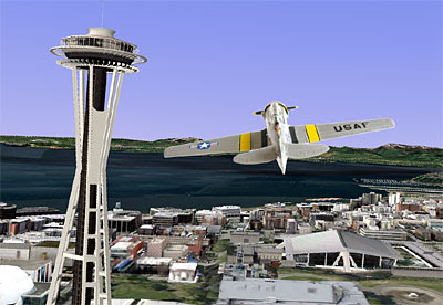
My current obsession is Google Earth's Flight Simulator, which I only recently discovered. The 3D graphics and the interactive possibilities seem astounding to me. To kick things off, I thought I would start by sharing an aircraft image which I created to work with the GE Flight Simulator. The download (T-6 Texan.kmz) is available from my web site.


The KML script that powers the T-6 Texan was developed by Amir B and featured in a posting at the Google Earth blog. His script is accompanied by a nice selection of plane images which include a bit of animation, and work very well. I thought it would be nice to make my own, so I photographed a detailed model of the classic T-6 trainer and manipulated it in Photoshop to be a drop-in replacement for Amir's ME-109.

To fly the T-6 Texan you will first need to download and install the current version of Google Earth as well as the above T-6 Texan.kmz file. Double clicking the kmz file will run Google Earth and display the plane in the center of the screen.

Start the animation by clicking on the button above the slider bar at the top of the page. Then, type in a "Fly To" destination and press Enter to zoom there. To start the flight, click "Tools/Enter Flight Simulator", or Ctrl+Alt+A. At that point you will be offered the option of two types of aircraft, an F16 jet or a prop-driven Cirrus SR22. The performance characteristics of the T-6 Texan are similar to the SR22, so that is the one I usually choose. Click your mouse on the screen at the start of the flight to obtain control, then move the cursor left, right, up and down to navigate. The PgUp and PgDn keys control the throttle.

Additional instructions for using the Google Earth Flight Simulator are linked in the posting cited above.